![Klir_Logo_Colour-B.png]](https://knowledgehub.klir.com/hs-fs/hubfs/Klir_Logo_Colour-B.png?width=181&height=90&name=Klir_Logo_Colour-B.png)
Your team already keeps maps and location data in GIS. The Klir GIS integration brings that same information into the Klir embedded map, right next to the operational data you work with every day.
This article covers what the integration does, the three integration levels, how we support setup and what we'll need from you to get started.
The big picture: Integrate GIS base maps and layers from your existing GIS system into Klir.
In this article
- What you can do
- Where you’ll see maps in Klir
- Choose your level
- How we support you
- What we need from you
- How setup works
- Quick troubleshooting
What you can do
Klir works with ESRI ArcGIS. Once your integration is set up, you can:
- See records on the map. Location points for records such as facilities and locations appear on the embedded map.
- Choose your base map. Pick the background style that suits your team, such as streets, navigation or night view.
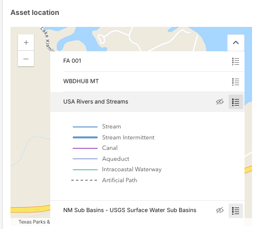
- Add your own layers. Bring in public and private layers from ArcGIS Online or ArcGIS Enterprise, stacked in the order you choose.
- Control what you see. Turn layers on or off from the Table of Contents panel, and collapse it when you need more room.
- Explore the details. Click a feature on a layer to see its properties in a pop-up.
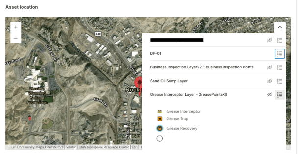
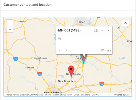
Some layers only appear at certain zoom levels, based on how they're set up in ArcGIS.
Where you’ll see maps in Klir
Once your integration is live, maps show up across Klir wherever location matters. That might be when you’re spotting compliance trends, reviewing facility assets or heading out to an inspection.
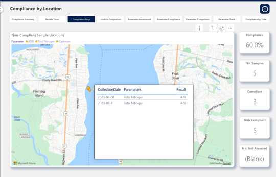
Compliance Map (All products)
Find it under Compliance. Your monitoring locations appear as points on an interactive map, next to overall compliance percentage cards. Use the Parameter Slicer at the top to switch between analytes, such as copper, zinc or arsenic, and quickly spot areas where non-compliance is clustering.
Asset and facility profiles (Community)
Go to Customers, select a customer and facility, then open the Assets tab. The embedded map pins each location by its latitude and longitude. It uses separate markers for the asset itself, such as a discharge pipe or backflow assembly, and for its associated monitoring location.
Inspections and the Klir Mobile App (Community)
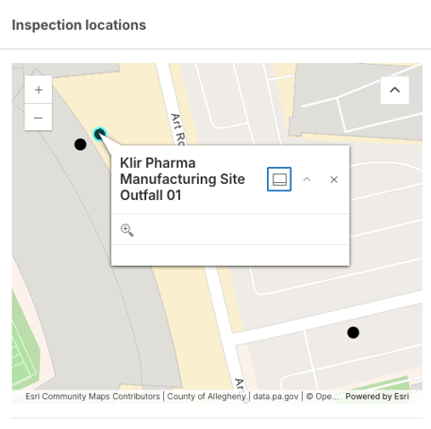
Open any assigned inspection and go to the Details tab. An expandable map shows the facility’s exact location. In the field, inspectors can tap the navigation icon to open those coordinates in their device’s map app, like Google Maps or Apple Maps, for turn-by-turn directions.
Choose your level
Each level builds on the one before it. Most utilities start at Level 1 or Level 2.
|
Level |
What you get |
What it takes |
|---|---|---|
|
Level 1 Public |
Public base map and public layers, plus location points for records such as facilities. |
Your API key, base map style and public layer details. |
|
Level 2 Private |
Everything in Level 1, plus your private base map and layers that normally need a sign in. |
Everything in Level 1, plus app credentials (a Client ID and Client Secret). |
|
Level 3 Two-way |
Everything in Level 2, plus multiple points on the map, Klir data feeding your ArcGIS layers and ArcGIS changes syncing back to Klir. |
Custom work, scoped in a discovery conversation with the Klir Product Team. |
Tip: Not sure which level fits? If anyone can open your layers without signing in, start with Level 1. If they need a login, go with Level 2. If you want data moving between Klir and ArcGIS, let's talk about Level 3.
How we support you
- Your Klir CSM is your point of contact from kickoff to go live.
- Klir handles the configuration. GIS settings live in your Klir tenant configuration, which our team manages for you.
- Your GIS team owns your ArcGIS content. Klir reads your layers directly from ArcGIS, so updates you make to that content show up in Klir.
- Changes are easy. To add, remove or reorder layers or switch base maps later, just send the details to your CSM.
What we need from you
Your GIS administrator will usually have, or can quickly create, everything on this list.
|
Send us |
What it is and where to find it |
Level |
|---|---|---|
|
ArcGIS API key |
Lets Klir access ArcGIS base maps and tracks usage against your account. Create one in your ArcGIS developer credentials. |
1, 2, 3 |
|
Base map style (optional) |
The style name, such as arcgis-navigation or arcgis-streets-night, from the ArcGIS basemap styles. We use arcgis-navigation by default.
Visit the ArcGIS Basemap Styles page. |
1, 2, 3 |
|
Layer list |
The name, URL and order for each layer (see below). Copy each layer's URL from the ArcGIS REST services directory. |
1, 2, 3 |
|
Client ID and Client Secret |
App credentials that let Klir securely read your private layers. Register an OAuth 2.0 app in your ArcGIS organization to get them. |
2, 3 |
|
Your use case |
A short description of what you'd like Klir and ArcGIS to do together. |
3 |


Sharing your layer list
For each layer, send the order (0 sits at the bottom, 1 on top of 0, and so on), the layer name you'd like to see in Klir and the layer URL. A simple list works perfectly:
|
Order |
Layer name |
Layer URL |
|---|---|---|
|
0 |
Service area boundary |
https://.../FeatureServer/0 |
|
1 |
Water mains |
https://.../FeatureServer/1 |
|
2 |
Sampling stations |
https://.../FeatureServer/2 |
Watch out: Your API key, Client ID and Client Secret work like passwords. Please don't send them by email, support ticket or chat. Your Klir CSM will confirm a secure way to share them.
How setup works
- Kickoff. Your CSM confirms the right level and the maps and layers you'd like in Klir.
- Gather your details. Your GIS team pulls together the items on the checklist.
- Share them securely. Send everything to your CSM using the secure method we confirm with you.
- Klir configures your map. Our team adds your details to your tenant configuration.
- Review and go live. We check the map together, your team confirms it looks right, and you're ready to go.
Once we have everything, your CSM will confirm the expected turnaround. For Level 3, scope and timing are agreed during discovery with the Klir Product Team.
Quick troubleshooting
|
If this happens |
Try this first |
|---|---|
|
A layer isn't showing on the map |
Check that it's turned on in the Table of Contents, then zoom in or out. If it's still missing, check whether its sharing settings changed in ArcGIS. |
|
A private layer won't load |
Check whether your ArcGIS app credentials were changed recently. If so, let your CSM know so we can update them. |
|
A location moved in ArcGIS, but Klir shows the old spot |
Syncing ArcGIS changes back to Klir is part of Level 3. Reach out to your CSM to talk through options. |
[Screenshot: Table of Contents panel with one layer toggled off, next to the map zoom controls]
Still stuck? Send your CSM the layer name, what you expected to see, a screenshot showing the zoom level and when it last worked.
What's next: Ready to get started? Reach out to your Klir CSM to book a kickoff, and start gathering the checklist items with your GIS team.